Geolocate

Miyoshi topographic map

Click on the map to display elevation.

About this map

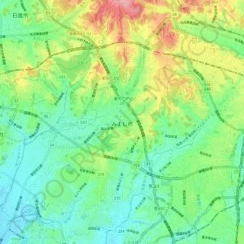
Name: Miyoshi topographic map, elevation, terrain.

Location: Miyoshi, Aichi Prefecture, 470-0224, Japan (35.05504 137.04494 35.14474 137.13027)

Average elevation: 62 m

Minimum elevation: 16 m

Maximum elevation: 156 m

👉 Easily get elevation data in JSON, GeoTIFF and KML formats using Elevation API
Thank you for supporting this site ❤️
Make a donation

Gear up for your next adventure:

As an Amazon Associate, this site earns from qualifying purchases at no extra cost to you.

Gear up for your next adventure:

🦶Orthotic Hiking Insoles - Extra arch support for long-distance topographic treks
🔑Heavy Duty Carabiners - Secure gear to the outside of your pack for easy access
🪢Paracord - Multi-purpose survival cord
🧯Animal Deterrent Spray - Safety spray for wildlife
🧊Insulated Cooler Bags - Keep food fresh for day trips to remote geographic sites

As an Amazon Associate, this site earns from qualifying purchases at no extra cost to you.