
Make a donation
Gear up for your next adventure:
As an Amazon Associate, this site earns from qualifying purchases at no extra cost to you.
Kfar Shaul topographic map
Click on the map to display elevation.
Make a donation
Gear up for your next adventure:
As an Amazon Associate, this site earns from qualifying purchases at no extra cost to you.
About this map
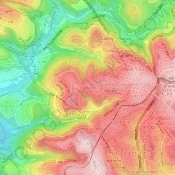
Name: Kfar Shaul topographic map, elevation, terrain.
Average elevation: 703 m
Minimum elevation: 529 m
Maximum elevation: 836 m
Make a donation
Gear up for your next adventure:
As an Amazon Associate, this site earns from qualifying purchases at no extra cost to you.
Other topographic maps
Click on a map to view its topography, its elevation and its terrain.
Temple Mount
Israel > Jerusalem District > Jerusalem
The exact moment when the concept of the Mount as a topographical feature separate from the Temple or the city itself first came into existence is a matter of debate among scholars. According to Eliav, it was during the first century CE, after the destruction of the Second Temple. Shahar and Shatzman reached…
Average elevation: 740 m
Make a donation
Gear up for your next adventure:
As an Amazon Associate, this site earns from qualifying purchases at no extra cost to you.