
Make a donation
Gear up for your next adventure:
As an Amazon Associate, this site earns from qualifying purchases at no extra cost to you.
Nabburg topographic map
Click on the map to display elevation.
Make a donation
Gear up for your next adventure:
As an Amazon Associate, this site earns from qualifying purchases at no extra cost to you.
About this map
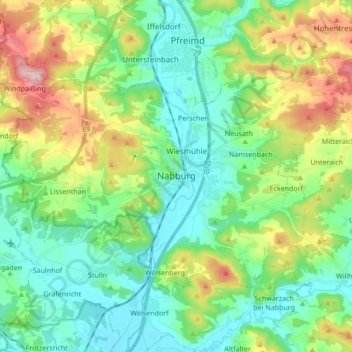
Name: Nabburg topographic map, elevation, terrain.
Average elevation: 435 m
Minimum elevation: 358 m
Maximum elevation: 620 m
Make a donation
Gear up for your next adventure:
As an Amazon Associate, this site earns from qualifying purchases at no extra cost to you.
Other topographic maps
Click on a map to view its topography, its elevation and its terrain.
Vorderkohlstetten
Deutschland > Bayern > Landkreis Schwandorf > Nittenau > Hof am Regen
Average elevation: 429 m
Wildstein
Deutschland > Bayern > Landkreis Schwandorf
1840 kam es zur Bildung „eines Landgerichts I. Klasse in Oberviechtach“. Das Landgericht Oberviechtach stimmte dem Ersuchen der Wildsteiner zu, die Regierung weigerte sich wegen der höheren Kosten für die Verwaltung. Spätestens 1864 war Wildstein wieder eigenständige Gemeinde.
Average elevation: 646 m
Make a donation
Gear up for your next adventure:
As an Amazon Associate, this site earns from qualifying purchases at no extra cost to you.
Ebersdorf
Deutschland > Bayern > Landkreis Schwandorf > Neunburg vorm Wald > Pissau
Average elevation: 484 m
Make a donation
Gear up for your next adventure:
As an Amazon Associate, this site earns from qualifying purchases at no extra cost to you.
Pfahl
Deutschland > Bayern > Landkreis Schwandorf > Neunburg vorm Wald > Hofenstetten
Average elevation: 484 m
Wackenried
Deutschland > Bayern > Landkreis Schwandorf > Bruck i.d.OPf. > Sollbach
Average elevation: 404 m
Make a donation
Gear up for your next adventure:
As an Amazon Associate, this site earns from qualifying purchases at no extra cost to you.
Obermainsbach
Deutschland > Bayern > Landkreis Schwandorf > Nittenau > Bleich
Average elevation: 385 m
Bodenwöhr
Deutschland > Bayern > Landkreis Schwandorf > Bodenwöhr > Bodenwöhr
Average elevation: 403 m
Make a donation
Gear up for your next adventure:
As an Amazon Associate, this site earns from qualifying purchases at no extra cost to you.
Schwarzhof
Deutschland > Bayern > Landkreis Schwandorf > Maxhütte-Haidhof > Ponholz
Average elevation: 384 m
Roßbach
Deutschland > Bayern > Landkreis Schwandorf > Maxhütte-Haidhof > Ponholz
Average elevation: 401 m
Büchlhof
Deutschland > Bayern > Landkreis Schwandorf > Neunburg vorm Wald > Kemnath b.Fuhrn
Average elevation: 441 m
Make a donation
Gear up for your next adventure:
As an Amazon Associate, this site earns from qualifying purchases at no extra cost to you.
Make a donation
Gear up for your next adventure:
As an Amazon Associate, this site earns from qualifying purchases at no extra cost to you.
Käfermühle
Deutschland > Bayern > Landkreis Schwandorf > Oberviechtach > Tressenried
Average elevation: 566 m
Make a donation
Gear up for your next adventure:
As an Amazon Associate, this site earns from qualifying purchases at no extra cost to you.
Make a donation
Gear up for your next adventure:
As an Amazon Associate, this site earns from qualifying purchases at no extra cost to you.
Weihern
Deutschland > Bayern > Landkreis Schwandorf > Pfreimd
1541 erwirkte Georg von Prandt von Kaiser Karl V. einen persönlichen Schutz- und Geleitbrief für sich und seine Familie. Weitere Gerichtsurteile aus den Jahren 1546, 1547, 1548 und 1551 wurden, soweit sie Prandt schuldig sprachen, vom kaiserlichen Kammergericht aufgehoben. Auch Bußgeldforderungen der Opfer…
Average elevation: 454 m
Make a donation
Gear up for your next adventure:
As an Amazon Associate, this site earns from qualifying purchases at no extra cost to you.
Gaisthal
Deutschland > Bayern > Landkreis Schwandorf > Schönsee
Gaisthal liegt an der Nordwestseite des Frauensteins am Fluss Ascha. Die Hauptstraßen des Ortes sind die Staatsstraßen 2159 und 2152. Schönsee liegt rund 4,7 Kilometer Luftlinie entfernt. Gaisthal liegt auf einer Höhe von rund 530 m ü. NN.
Average elevation: 619 m
Muschenried
Deutschland > Bayern > Landkreis Schwandorf
Östlich der Ortschaft Muschenried liegt ein großes Waldgebiet, das Teil des weithin sichtbaren Frauensteins ist. Dessen höchste Erhebung ist der Signalberg (887 m). Auf dem Frauenstein befindet sich auch die Burgruine der Burg Frauenstein (in 835 m Höhe), Muschenried liegt im Naturpark Oberpfälzer Wald,…
Average elevation: 518 m
Make a donation
Gear up for your next adventure:
As an Amazon Associate, this site earns from qualifying purchases at no extra cost to you.
Penting
Deutschland > Bayern > Landkreis Schwandorf > Neunburg vorm Wald
Penting liegt auf 506 m ü. NHN circa fünf Kilometer südlich von Neunburg vorm Wald auf einem Höhenzug, der das Schwarzachtal vom Bodenwöhrer Becken trennt. Durch diese exponierte Lage ist der Ort besonders vom Schwarzachtal aus schon von weitem zu sehen.
Average elevation: 470 m
Stefling
Deutschland > Bayern > Landkreis Schwandorf > Nittenau
Annahaid | Asang | Auhof | Bachbügl | Bergham | Berghof | Berglarn | Bleich | Bodenstein | Brunn | Diepenried | Dobl | Dürrmaul | Eckartsreuth | Eichlgütl | Elendhof | Entermainsbach | Eschlbach | Fichtenhof | Fischbach | Forsting | Geiseck | Goppeltshof | Gunt | Hadriwa (Nittenau) | Haiderhöf |…
Average elevation: 429 m
Wutzelskühn
Deutschland > Bayern > Landkreis Schwandorf > Neunburg vorm Wald > Penting
Das Dorf Wutzelskühn liegt circa fünf Kilometer südwestlich von Neunburg vorm Wald und einen Kilometer vom Ortsteil Penting entfernt auf einem Höhenzug über dem Schwarzachtal.
Average elevation: 474 m
Make a donation
Gear up for your next adventure:
As an Amazon Associate, this site earns from qualifying purchases at no extra cost to you.
Thannmühle
Deutschland > Bayern > Landkreis Schwandorf > Neunburg vorm Wald > Thann
Average elevation: 510 m
Oberpfälzer Wald
Deutschland > Bayern > Landkreis Schwandorf > Nabburg > Namsenbach > Richtmühle
Average elevation: 450 m
Make a donation
Gear up for your next adventure:
As an Amazon Associate, this site earns from qualifying purchases at no extra cost to you.
Wölsendorf
Deutschland > Bayern > Landkreis Schwandorf > Schwarzach b.Nabburg > Wölsendorf
Wölsendorf liegt in der Region Oberpfalz-Nord an der Naab zwischen Nabburg und Schwarzenfeld am Fuße des Wolfsberges (530 m). Die Höhen des Naabdurchbruchs, begrenzt durch den Mühlberg (428 m) bei Stulln und Brensdorf und den Lehenbühl (457 m) bei Wölsendorf, haben hier einen Abstand von etwa 200 Meter.…
Average elevation: 393 m
Hof am Regen
Deutschland > Bayern > Landkreis Schwandorf > Nittenau > Hof am Regen
Average elevation: 418 m
Make a donation
Gear up for your next adventure:
As an Amazon Associate, this site earns from qualifying purchases at no extra cost to you.
Schwallbach
Deutschland > Bayern > Landkreis Schwandorf > Wernberg-Köblitz > Neunaigen
Average elevation: 420 m
Make a donation
Gear up for your next adventure:
As an Amazon Associate, this site earns from qualifying purchases at no extra cost to you.
Make a donation
Gear up for your next adventure:
As an Amazon Associate, this site earns from qualifying purchases at no extra cost to you.