Geolocate

Dingwall topographic map

Click on the map to display elevation.

About this map

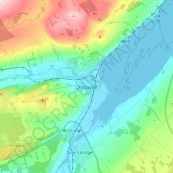
Name: Dingwall topographic map, elevation, terrain.

Location: Dingwall, Highland, Scotland, IV15 9RU, United Kingdom (57.55548 -4.46843 57.63548 -4.38843)

Average elevation: 94 m

Minimum elevation: 0 m

Maximum elevation: 353 m

Other topographic maps

Click on a map to view its topography, its elevation and its terrain.

Strathnairn

United Kingdom > Scotland > Highland > Daviot

Average elevation: 268 m

Loch Ness

United Kingdom > Scotland > Highland > Dores

Average elevation: 340 m

Whitebridge

United Kingdom > Scotland > Highland

Average elevation: 223 m

Glen Coe

United Kingdom > Scotland > Highland > Glencoe

Average elevation: 414 m

Gear up for your next adventure:

🧳Outdoor Travel Organizers - Gear organization accessories
🥾Hiking Shoes - Lightweight hiking shoes for day hikes
🧥Down Jackets - Insulated jackets for cold weather
🩹First Aid Kits - Emergency kits for hiking
🦯Trekking Poles - Walking poles for hiking stability

As an Amazon Associate, this site earns from qualifying purchases at no extra cost to you.