Geolocate

Manuto topographic map

Click on the map to display elevation.

About this map

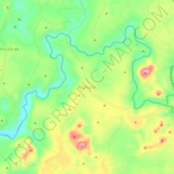
Name: Manuto topographic map, elevation, terrain.

Location: Manuto, Quezon, Bukidnon, Northern Mindanao, 8715, Philippines (7.67893 125.06934 7.71893 125.10934)

Average elevation: 272 m

Minimum elevation: 201 m

Maximum elevation: 367 m

Other topographic maps

Click on a map to view its topography, its elevation and its terrain.

Manuto River

Philippines > Bukidnon > Quezon > Cawayan

Average elevation: 405 m

Pulangi Lake

Philippines > Bukidnon > Quezon

Average elevation: 301 m

Gear up for your next adventure:

🎒Tactical Waist Packs - Quick access to your compass, phone, and snacks while walking
📕Australia Maps - Maps covering Australian regions
💧Personal Water Filters - Drink safely from streams and lakes identified on your map
🧢Wide Brim Sun Hats - Maximum coverage for the face and neck while out in the open
📡Weather Radios - Emergency weather radios

As an Amazon Associate, this site earns from qualifying purchases at no extra cost to you.