
Butzbach topographic map
Interactive map
Click on the map to display elevation.
About this map
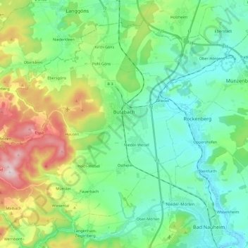
Name: Butzbach topographic map, elevation, terrain.
Location: Butzbach, Wetteraukreis, Hessen, 35510, Deutschland (50.36759 8.51401 50.48528 8.73678)
Average elevation: 238 m
Minimum elevation: 132 m
Maximum elevation: 516 m
Butzbach besteht aus den Stadtteilen Bodenrod, Butzbach (Kernstadt), Ebersgöns, Fauerbach vor der Höhe, Griedel, Hausen-Oes, Hoch-Weisel, Kirch-Göns, Maibach, Münster, Nieder-Weisel, Ostheim, Pohl-Göns und Wiesental.
Other topographic maps
Click on a map to view its topography, its elevation and its terrain.
Maibach
Deutschland > Hessen > Butzbach > Maibach
Maibach, Butzbach, Wetteraukreis, Hessen, Deutschland
Average elevation: 348 m