
Wadersloh topographic map
Interactive map
Click on the map to display elevation.
About this map
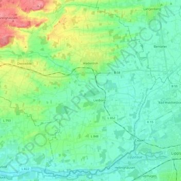
Name: Wadersloh topographic map, elevation, terrain.
Location: Wadersloh, Kreis Warendorf, North Rhine-Westphalia, Germany (51.65810 8.11614 51.77855 8.32009)
Average elevation: 87 m
Minimum elevation: 67 m
Maximum elevation: 146 m
Other topographic maps
Click on a map to view its topography, its elevation and its terrain.
Ahlen
Germany > North Rhine-Westphalia > Kreis Warendorf
Ahlen, Kreis Warendorf, North Rhine-Westphalia, Germany
Average elevation: 81 m
Drensteinfurt
Germany > North Rhine-Westphalia > Kreis Warendorf
Drensteinfurt, Kreis Warendorf, North Rhine-Westphalia, 48317, Germany
Average elevation: 69 m
Vellern
Germany > North Rhine-Westphalia > Kreis Warendorf > Beckum
Vellern, Beckum, Kreis Warendorf, North Rhine-Westphalia, 59269, Germany
Average elevation: 129 m
Oelde
Germany > North Rhine-Westphalia > Kreis Warendorf
Oelde, Kreis Warendorf, North Rhine-Westphalia, 59302, Germany
Average elevation: 100 m
Sassenberg
Germany > North Rhine-Westphalia > Kreis Warendorf
Sassenberg, Kreis Warendorf, North Rhine-Westphalia, 48336, Germany
Average elevation: 62 m