
Belleville topographic map
Interactive map
Click on the map to display elevation.
About this map
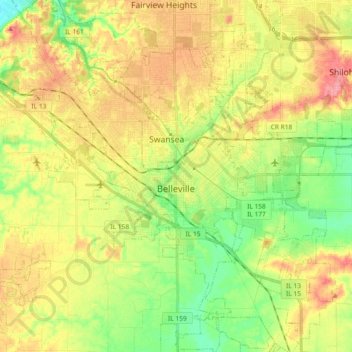
Name: Belleville topographic map, elevation, terrain.
Location: Belleville, Saint Clair County, Illinois, United States (38.44661 -90.08687 38.59082 -89.90517)
Average elevation: 163 m
Minimum elevation: 124 m
Maximum elevation: 205 m
Other topographic maps
Click on a map to view its topography, its elevation and its terrain.
Westview
United States > Illinois > Saint Clair County
Westview, Saint Clair County, Illinois, United States
Average elevation: 149 m
Freeburg
United States > Illinois > Saint Clair County
Freeburg, Saint Clair County, Illinois, 62243, United States
Average elevation: 152 m
Roachtown
United States > Illinois > Saint Clair County
Roachtown, Saint Clair County, Illinois, United States
Average elevation: 164 m
Marissa
United States > Illinois > Saint Clair County
Marissa, Saint Clair County, Illinois, United States
Average elevation: 138 m
Mascoutah
United States > Illinois > Saint Clair County
Mascoutah, Saint Clair County, Illinois, 62258, United States
Average elevation: 135 m
O'Fallon
United States > Illinois > Saint Clair County
O'Fallon, Saint Clair County, Illinois, 62269, United States
Average elevation: 164 m
Cahokia Mounds State Historic Site
United States > Illinois > Saint Clair County > Fairmont City
Cahokia Mounds State Historic Site, Fairmont City, Saint Clair County, Illinois, United States
Average elevation: 128 m
Smithton
United States > Illinois > Saint Clair County
Smithton, Saint Clair County, Illinois, United States
Average elevation: 147 m
Shiloh
United States > Illinois > Saint Clair County
Shiloh, Saint Clair County, Illinois, United States
Average elevation: 157 m
Fairview Heights
United States > Illinois > Saint Clair County
Fairview Heights, Saint Clair County, Illinois, 62208, United States
Average elevation: 173 m
Caseyville
United States > Illinois > Saint Clair County
Caseyville, Saint Clair County, Illinois, United States
Average elevation: 152 m
St. Libory
United States > Illinois > Saint Clair County > St. Libory
St. Libory, Saint Clair County, Illinois, 62282, United States
Average elevation: 128 m
Dutch Hollow
United States > Illinois > Saint Clair County > Belleville > Dutch Hollow
Dutch Hollow, Belleville, Saint Clair County, Illinois, 62223, United States
Average elevation: 170 m
Belleville
United States > Illinois > Saint Clair County > Belleville
Belleville, Saint Clair County, Illinois, 6220, United States
Average elevation: 162 m
Lebanon
United States > Illinois > Saint Clair County > Lebanon
Lebanon, Saint Clair County, Illinois, 62254, United States
Average elevation: 139 m
Shiloh
United States > Illinois > Saint Clair County > Shiloh > Shiloh
Shiloh, Saint Clair County, Illinois, 62269, United States
Average elevation: 158 m
Cahokia
United States > Illinois > Saint Clair County
Cahokia, Saint Clair County, Illinois, 62206, United States
Average elevation: 128 m
East St. Louis
United States > Illinois > Saint Clair County
East St. Louis, Saint Clair County, Illinois, United States
Average elevation: 130 m
Summerfield
United States > Illinois > Saint Clair County
Summerfield, Saint Clair County, Illinois, United States
Average elevation: 149 m