
Zagreb topographic map
Interactive map
Click on the map to display elevation.
About this map
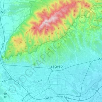
Name: Zagreb topographic map, elevation, terrain.
Location: Zagreb, City of Zagreb, Croatia (45.74733 15.82174 45.93800 16.10710)
Average elevation: 251 m
Minimum elevation: 99 m
Maximum elevation: 1,027 m
Zagreb (/ˈzɑːɡrɛb, ˈzæɡrɛb, zɑːˈɡrɛb/ ZAH-greb, ZAG-reb, zah-GREB; Croatian pronunciation: (listen)) is the capital and the largest city of Croatia. It is in the northwest of the country, along the Sava river, at the southern slopes of the Medvednica mountain. Zagreb lies at an elevation of approximately 122 m (400 ft) above sea level. The estimated population of the city in 2018 was 804,507. The population of the Zagreb urban agglomeration is 1,086,528, approximately a quarter of the total population of Croatia.
Other topographic maps
Click on a map to view its topography, its elevation and its terrain.
Trešnjevka - sjever
Trešnjevka - sjever, Zagreb, City of Zagreb, 10110, Croatia
Average elevation: 129 m