
Malekula topographic map
Interactive map
Click on the map to display elevation.
About this map
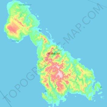
Name: Malekula topographic map, elevation, terrain.
Location: Malekula, Malampa, Vanuatu (-16.58954 167.15358 -15.87878 167.83526)
Average elevation: 69 m
Minimum elevation: 0 m
Maximum elevation: 843 m
It has a maximum elevation of 879 m. It is called Mt. Liambele. In 1768, Louis Antoine de Bougainville gave his name to the straits which separate Malakula from Santo.
Other topographic maps
Click on a map to view its topography, its elevation and its terrain.