Geolocate

L'Escoutet topographic map

Interactive map

Click on the map to display elevation.

About this map

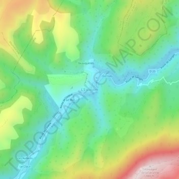
Name: L'Escoutet topographic map, elevation, terrain.

Location: L'Escoutet, Gorniès, Lodève, Hérault, Occitanie, France métropolitaine, 34190, France (43.86871 3.60373 43.90871 3.64373)

Average elevation: 444 m

Minimum elevation: 185 m

Maximum elevation: 933 m

Other topographic maps

Click on a map to view its topography, its elevation and its terrain.

Gorniès

France > Occitanie > Hérault > Gorniès > L'Escoutet

Gorniès, L'Escoutet, Gorniès, Lodève, Hérault, Occitanie, France métropolitaine, 34190, France

Average elevation: 427 m

Le Claux

France > Occitanie > Hérault > Gorniès

Le Claux, Gorniès, Lodève, Hérault, Occitanie, France métropolitaine, 34190, France

Average elevation: 497 m

Le Grenouillet

France > Occitanie > Hérault > Gorniès

Le Grenouillet, Gorniès, Lodève, Hérault, Occitanie, France métropolitaine, 34190, France

Average elevation: 509 m