
Make a donation
Gear up for your next adventure:
As an Amazon Associate, this site earns from qualifying purchases at no extra cost to you.
Nestos Municipality topographic map
Click on the map to display elevation.
Make a donation
Gear up for your next adventure:
As an Amazon Associate, this site earns from qualifying purchases at no extra cost to you.
About this map
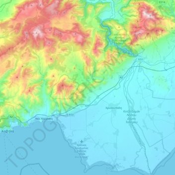
Name: Nestos Municipality topographic map, elevation, terrain.
Average elevation: 292 m
Minimum elevation: -3 m
Maximum elevation: 1,384 m
Make a donation
Gear up for your next adventure:
As an Amazon Associate, this site earns from qualifying purchases at no extra cost to you.
Other topographic maps
Click on a map to view its topography, its elevation and its terrain.
Kavala
Greece > Macedonia and Thrace > Kavala Regional Unit
On July 16, 2022, Meridian Flight 3032 crashed near the village. The Ukrainian-registered Antonov An-12BK was carrying 11.5 tons of ammunition from Niš to Dhaka when the plane began to lose altitude over the Aegean and turned around, but went down 35 kilometers west of Kavala Airport. All 8 crew members were…
Average elevation: 173 m
Στενά Νέστου
Greece > Macedonia and Thrace > Kavala Regional Unit > Paradisos
Average elevation: 449 m
Make a donation
Gear up for your next adventure:
As an Amazon Associate, this site earns from qualifying purchases at no extra cost to you.
Kavala
Greece > Macedonia and Thrace > Kavala Regional Unit
On July 16, 2022, Meridian Flight 3032 crashed nearby. The Ukrainian-registered Antonov An-12BK was carrying 11.5 tons of ammunition from Niš to Dhaka when the plane began to lose altitude over the Aegean and turned around, but went down 35 kilometers west of Kavala Airport. All 8 crew members were killed.
Average elevation: 173 m