
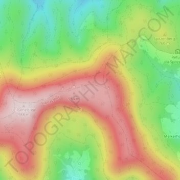
Taennchel topographic map
Interactive map
Click on the map to display elevation.
About this map
Name: Taennchel topographic map, elevation, terrain.
Average elevation: 740 m
Minimum elevation: 481 m
Maximum elevation: 988 m
Other topographic maps
Click on a map to view its topography, its elevation and its terrain.
Schelmenkopf
France > Grand Est > Haut-Rhin > Ribeauvillé
Schelmenkopf, Ribeauvillé, Colmar-Ribeauvillé, Haut-Rhin, Grand Est, France métropolitaine, 68150, France
Average elevation: 681 m
Dusenbach
France > Grand Est > Haut-Rhin > Ribeauvillé
Dusenbach, Ribeauvillé, Colmar-Ribeauvillé, Haut-Rhin, Grand Est, France métropolitaine, 68150, France
Average elevation: 507 m
La Pépinière
France > Grand Est > Haut-Rhin > Ribeauvillé
La Pépinière, Ribeauvillé, Colmar-Ribeauvillé, Haut-Rhin, Grand Est, France métropolitaine, 68150, France
Average elevation: 584 m
Chalet du Club Vosgiens Ribeauvillé
France > Grand Est > Haut-Rhin > Ribeauvillé > Schelmenkopf
Chalet du Club Vosgiens Ribeauvillé, Chemin du Schelmenkopf, Schelmenkopf, Ribeauvillé, Colmar-Ribeauvillé, Haut-Rhin, Grand Est, France métropolitaine, 68150, France
Average elevation: 700 m