
Ouray topographic map
Click on the map to display elevation.
Ouray
Ouray (/ˈjʊəreɪ/ YOOR-ay) is a home rule municipality that is the county seat of Ouray County, Colorado, United States. The city population was 898 as of the 2020 census. The Ouray Post Office has the ZIP Code 81427. Located at an elevation of 7,792 feet (2,375 m), Ouray's climate, natural alpine environment, and scenery have earned it the nickname "Switzerland of America".
About this map
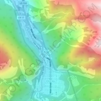
Name: Ouray topographic map, elevation, terrain.
Location: Ouray, Ouray County, Colorado, 81427, United States (38.01660 -107.68525 38.04735 -107.66123)
Average elevation: 2,717 m
Minimum elevation: 2,316 m
Maximum elevation: 3,431 m
Other topographic maps
Click on a map to view its topography, its elevation and its terrain.
Ridgway
United States > Colorado > Ouray County
Ridgway is situated in the Uncompahgre Valley at an elevation of 6,985 feet (2,129 m). The town is located on the San Juan Skyway, cradled in the heart of some of the most photographed mountains in the world. The nearby San Juan Mountain Range has 14 of Colorado's 53 peaks over 14,000 feet. Among them, 14,150…
Average elevation: 2,173 m