
l'Estartit topographic map
Interactive map
Click on the map to display elevation.
About this map
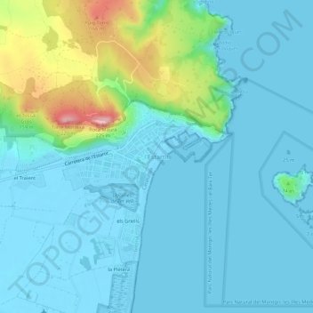
Name: l'Estartit topographic map, elevation, terrain.
Average elevation: 34 m
Minimum elevation: -5 m
Maximum elevation: 199 m
Other topographic maps
Click on a map to view its topography, its elevation and its terrain.
Castell del Mongrí
Espagne > Catalogne > Bas-Ampurdan > Torroella de Montgrí
Castell del Mongrí, Camí del cau d'en Calvet, Torroella de Montgrí, Bas-Ampurdan, Gérone, Catalogne, 17130, Espagne
Average elevation: 106 m