
Rothenbuhl topographic map
Interactive map
Click on the map to display elevation.
About this map
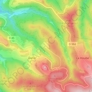
Name: Rothenbuhl topographic map, elevation, terrain.
Average elevation: 475 m
Minimum elevation: 279 m
Maximum elevation: 666 m
Other topographic maps
Click on a map to view its topography, its elevation and its terrain.
Borne Saint-Martin
France > Grand Est > Moselle > Dabo
Borne Saint-Martin, Dabo, Sarrebourg-Château-Salins, Moselle, Grand Est, France métropolitaine, 57850, France
Average elevation: 446 m
Tour de communication de La Hoube
France > Grand Est > Moselle > Dabo
Tour de communication de La Hoube, D 45, Dabo, Sarrebourg-Château-Salins, Moselle, Grand Est, France métropolitaine, France
Average elevation: 554 m