
Parque Nacional Laguna San Rafael topographic map
Interactive map
Click on the map to display elevation.
About this map
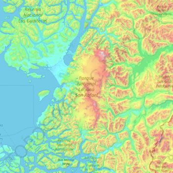
Name: Parque Nacional Laguna San Rafael topographic map, elevation, terrain.
Average elevation: 590 m
Minimum elevation: -3 m
Maximum elevation: 3,891 m
Other topographic maps
Click on a map to view its topography, its elevation and its terrain.
Glaciar Bernardo
Chile > Región Aysén del General Carlos Ibáñez del Campo > Provincia de Capitán Prat > Tortel
Glaciar Bernardo, Tortel, Provincia de Capitán Prat, Región Aysén del General Carlos Ibáñez del Campo, Chile
Average elevation: 472 m