
Thank you for supporting this site ❤️
Make a donation
Make a donation
Gear up for your next adventure:
As an Amazon Associate, this site earns from qualifying purchases at no extra cost to you.
Córdoba topographic map
Click on the map to display elevation.
Thank you for supporting this site ❤️
Make a donation
Make a donation
Gear up for your next adventure:
As an Amazon Associate, this site earns from qualifying purchases at no extra cost to you.
About this map
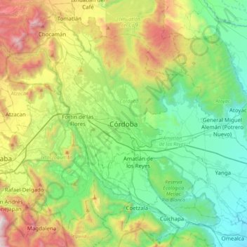
Name: Córdoba topographic map, elevation, terrain.
Location: Córdoba, Veracruz, 94500, Mexico (18.73447 -97.09529 19.05447 -96.77529)
Average elevation: 1,030 m
Minimum elevation: 372 m
Maximum elevation: 2,532 m
Thank you for supporting this site ❤️
Make a donation
Make a donation
Gear up for your next adventure:
As an Amazon Associate, this site earns from qualifying purchases at no extra cost to you.