
Make a donation
Gear up for your next adventure:
As an Amazon Associate, this site earns from qualifying purchases at no extra cost to you.
Bad Urach topographic map
Click on the map to display elevation.
Make a donation
Gear up for your next adventure:
As an Amazon Associate, this site earns from qualifying purchases at no extra cost to you.
About this map
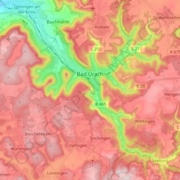
Name: Bad Urach topographic map, elevation, terrain.
Average elevation: 668 m
Minimum elevation: 375 m
Maximum elevation: 847 m
Make a donation
Gear up for your next adventure:
As an Amazon Associate, this site earns from qualifying purchases at no extra cost to you.
Other topographic maps
Click on a map to view its topography, its elevation and its terrain.
Ableitung Erms
Germany > Baden-Württemberg > Landkreis Reutlingen > Dettingen an der Erms
Average elevation: 482 m
Make a donation
Gear up for your next adventure:
As an Amazon Associate, this site earns from qualifying purchases at no extra cost to you.
Untergreifenstein
Germany > Baden-Württemberg > Landkreis Reutlingen > Lichtenstein
Average elevation: 661 m
Make a donation
Gear up for your next adventure:
As an Amazon Associate, this site earns from qualifying purchases at no extra cost to you.