
Rum Jungle topographic map
Interactive map
Click on the map to display elevation.
About this map
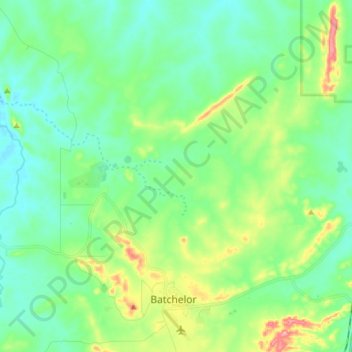
Name: Rum Jungle topographic map, elevation, terrain.
Location: Rum Jungle, Coomalie Shire, Northern Territory, Australia (-13.05041 130.94552 -12.93898 131.09840)
Average elevation: 79 m
Minimum elevation: 45 m
Maximum elevation: 174 m
Other topographic maps
Click on a map to view its topography, its elevation and its terrain.
Eva Valley
Eva Valley, Coomalie Shire, Northern Territory, Australia
Average elevation: 97 m
Adelaide River
Australia > Coomalie Shire > Adelaide River
Adelaide River, Coomalie Shire, Northern Territory, 0846, Australia
Average elevation: 61 m
Batchelor
Batchelor, Coomalie Shire, Northern Territory, 0845, Australia
Average elevation: 95 m
Adelaide River
Adelaide River, Coomalie Shire, Northern Territory, 0846, Australia
Average elevation: 68 m
Batchelor
Australia > Coomalie Shire > Batchelor
Batchelor, Coomalie Shire, Northern Territory, 0845, Australia
Average elevation: 97 m
Amangal
Australia > Coomalie Shire > Adelaide River
Amangal, Adelaide River, Coomalie Shire, Northern Territory, 0846, Australia
Average elevation: 64 m