
Cherry Gardens topographic map
Interactive map
Click on the map to display elevation.
About this map
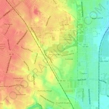
Name: Cherry Gardens topographic map, elevation, terrain.
Location: Cherry Gardens, Richmond, Virginia, 23249, United States (37.46209 -77.47915 37.50209 -77.43915)
Average elevation: 43 m
Minimum elevation: 11 m
Maximum elevation: 67 m
Other topographic maps
Click on a map to view its topography, its elevation and its terrain.
Scottdale
United States > Virginia > Richmond
Scottdale, Richmond, Virginia, 23249, United States
Average elevation: 36 m
Fernleigh
United States > Virginia > Richmond > Fernleigh
Fernleigh, Richmond, Virginia, 23235, United States
Average elevation: 77 m