

Ipswich topographic map
Click on the map to display elevation.
Ipswich
Ipswich experiences an oceanic climate, like the rest of the British Isles, with a narrow range of temperature and rainfall spread evenly throughout the year. One of the two nearest for which data is available is East Bergholt, about 7 miles (11 km) south west of the town centre and at a similar elevation, and similar river valley/estuary situation. The average July maximum of 23.2 °C (73.8 °F) is the third-highest for a major settlement in the country, behind London and Colchester, illustrating the relative warmth of the area during the summer part of the year. The record maximum is 35.2 °C (95.4 °F), set during August 2003. Typically, 24.9 days of the year will record a maximum temperature of 25.1 °C (77.2 °F) or above, and the warmest day of the year should reach 30.0 °C (86.0 °F), on average.
About this map
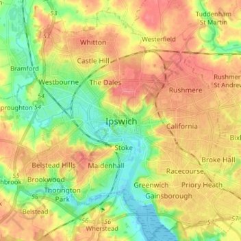
Name: Ipswich topographic map, elevation, terrain.
Location: Ipswich, Suffolk, England, IP1 1DD, United Kingdom (52.01793 1.11281 52.09793 1.19281)
Average elevation: 30 m
Minimum elevation: -3 m
Maximum elevation: 56 m