
Thank you for supporting this site ❤️
Make a donation
Make a donation
Gear up for your next adventure:
As an Amazon Associate, this site earns from qualifying purchases at no extra cost to you.
Kerugoya topographic map
Click on the map to display elevation.
Thank you for supporting this site ❤️
Make a donation
Make a donation
Gear up for your next adventure:
As an Amazon Associate, this site earns from qualifying purchases at no extra cost to you.
About this map
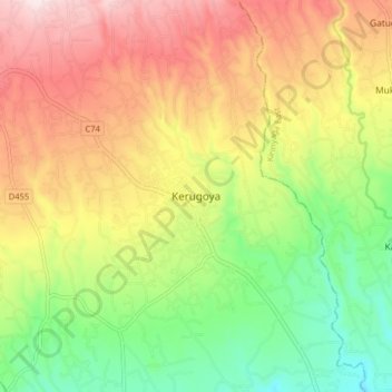
Name: Kerugoya topographic map, elevation, terrain.
Location: Kerugoya, Kirinyaga Central, Kirinyaga County, 10300, Kenya (-0.53633 37.23858 -0.45633 37.31858)
Average elevation: 1,552 m
Minimum elevation: 1,340 m
Maximum elevation: 1,788 m
Thank you for supporting this site ❤️
Make a donation
Make a donation
Gear up for your next adventure:
As an Amazon Associate, this site earns from qualifying purchases at no extra cost to you.