
Western topographic map
Interactive map
Click on the map to display elevation.
About this map
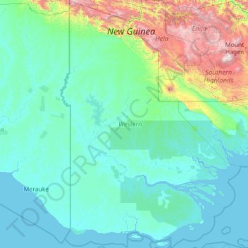
Name: Western topographic map, elevation, terrain.
Location: Western, Papua Region, Papua New Guinea (-9.46925 140.84166 -4.98715 144.12306)
Average elevation: 373 m
Minimum elevation: -2 m
Maximum elevation: 4,166 m
Other topographic maps
Click on a map to view its topography, its elevation and its terrain.
Ningerum
Ningerum, Western, Southern Region, Papua New Guinea
Average elevation: 70 m
Weam
Papua New Guinea > Western > Weam
Weam, Morehead District, Western, Papua Region, Papua New Guinea
Average elevation: 9 m
Kiunga
Papua New Guinea > Western > Kiunga > Kiunga
Kiunga, Kiunga District, Western, Papua Region, Papua New Guinea
Average elevation: 25 m
Badu Island
Badu Island, Daru District, Western, Papua Region, Papua New Guinea
Average elevation: 11 m