
Vanclans topographic map
Interactive map
Click on the map to display elevation.
About this map
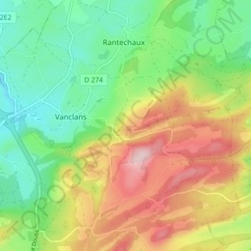
Name: Vanclans topographic map, elevation, terrain.
Average elevation: 805 m
Minimum elevation: 689 m
Maximum elevation: 973 m
Other topographic maps
Click on a map to view its topography, its elevation and its terrain.
Les Premiers-Sapins
France > Bourgogne-Franche-Comté > Les Premiers-Sapins
Les Premiers-Sapins, Pontarlier, Doubs, Bourgogne-Franche-Comté, France métropolitaine, 25580, France
Average elevation: 769 m
Nods
France > Bourgogne-Franche-Comté > Les Premiers-Sapins
Nods, Les Premiers-Sapins, Pontarlier, Doubs, Bourgogne-Franche-Comté, France métropolitaine, 25580, France
Average elevation: 778 m