
Komlói járás topographic map
Interactive map
Click on the map to display elevation.
About this map
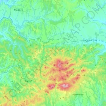
Name: Komlói járás topographic map, elevation, terrain.
Average elevation: 237 m
Minimum elevation: 111 m
Maximum elevation: 670 m
Other topographic maps
Click on a map to view its topography, its elevation and its terrain.
Geresdlak
Geresdlak, Pécsváradi járás, Baranya vármegye, Transdanubie méridionale, Transdanubie, 7733, Hongrie
Average elevation: 199 m
Mohácsi Történelmi Emlékhely
Hongrie > Baranya vármegye > Sátorhely
Mohácsi Történelmi Emlékhely, 8, Sátorhely, Mohácsi járás, Baranya vármegye, Transdanubie méridionale, Transdanubie, 7785, Hongrie
Average elevation: 91 m
Mohács
Mohács, Mohácsi járás, Baranya vármegye, Transdanubie méridionale, Transdanubie, Hongrie
Average elevation: 108 m