
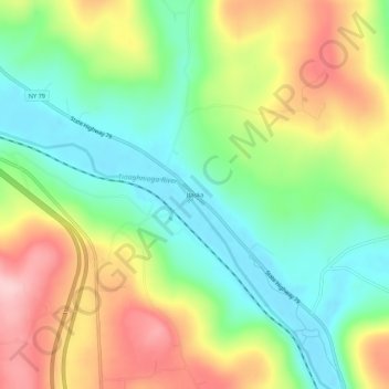
Itaska topographic map
Interactive map
Click on the map to display elevation.
About this map
Name: Itaska topographic map, elevation, terrain.
Average elevation: 360 m
Minimum elevation: 276 m
Maximum elevation: 480 m
Other topographic maps
Click on a map to view its topography, its elevation and its terrain.
City of Binghamton
United States > New York > Broome County
City of Binghamton, Broome County, New York, 13905, United States
Average elevation: 321 m
Lester
United States > New York > Broome County
Lester, Town of Windsor, Broome County, New York, United States
Average elevation: 482 m
Vestal Center
United States > New York > Broome County > Town of Vestal
Vestal Center, Town of Vestal, Broome County, New York, 13850, United States
Average elevation: 381 m
Town of Vestal
United States > New York > Broome County
Town of Vestal, Broome County, New York, United States
Average elevation: 372 m
Port Crane
United States > New York > Broome County
Port Crane, Town of Fenton, Broome County, New York, 13745, United States
Average elevation: 346 m
Ouaquaga
United States > New York > Broome County
Ouaquaga, Town of Colesville, Broome County, New York, 13826, United States
Average elevation: 352 m
Nineveh
United States > New York > Broome County
Nineveh, Town of Colesville, Broome County, New York, United States
Average elevation: 338 m
Village of Port Dickinson
United States > New York > Broome County
Village of Port Dickinson, Town of Dickinson, Broome County, New York, United States
Average elevation: 288 m
Town of Lisle
United States > New York > Broome County
Town of Lisle, Broome County, New York, United States
Average elevation: 380 m
Glen Aubrey
United States > New York > Broome County > Town of Nanticoke
Glen Aubrey, Town of Nanticoke, Broome County, New York, United States
Average elevation: 372 m
Conklin Center
United States > New York > Broome County > Town of Conklin
Conklin Center, Town of Conklin, Broome County, New York, 13748, United States
Average elevation: 311 m
West Windsor
United States > New York > Broome County
West Windsor, Town of Windsor, Broome County, New York, 13795, United States
Average elevation: 457 m
Kopernik Observatory & Science Center
United States > New York > Broome County > Town of Vestal > Tracy Creek
Kopernik Observatory & Science Center, 698, Underwood Road, Tracy Creek, Town of Vestal, Broome County, New York, 13850, United States
Average elevation: 452 m
Conklin Forks
United States > New York > Broome County > Town of Conklin
Conklin Forks, Town of Conklin, Broome County, New York, United States
Average elevation: 405 m
Town of Fenton
United States > New York > Broome County
Town of Fenton, Broome County, New York, United States, Chenango Valley State Park
Average elevation: 315 m
Town of Fenton
United States > New York > Broome County
Town of Fenton, Broome County, New York, United States
Average elevation: 376 m
Doraville
United States > New York > Broome County
Doraville, Town of Colesville, Broome County, New York, 13813, United States
Average elevation: 370 m
Town of Colesville
United States > New York > Broome County
Town of Colesville, Broome County, New York, United States
Average elevation: 423 m
Town of Sanford
United States > New York > Broome County
Town of Sanford, Broome County, New York, 13754, United States
Average elevation: 462 m
Harpursville
United States > New York > Broome County
Harpursville, Town of Colesville, Broome County, New York, 13787, United States
Average elevation: 351 m
Ross Corners
United States > New York > Broome County > Town of Vestal
Ross Corners, Town of Vestal, Broome County, New York, United States
Average elevation: 304 m
Town of Triangle
United States > New York > Broome County
Town of Triangle, Broome County, New York, 13862, United States
Average elevation: 409 m
Town of Windsor
United States > New York > Broome County
Town of Windsor, Broome County, New York, United States
Average elevation: 434 m
Center Lisle
United States > New York > Broome County > Town of Lisle
Center Lisle, Town of Lisle, Broome County, New York, 13797, United States
Average elevation: 384 m
Endwell
United States > New York > Broome County
Endwell, Town of Union, Broome County, New York, United States
Average elevation: 298 m
Town of Maine
United States > New York > Broome County
Town of Maine, Broome County, New York, 13802, United States
Average elevation: 390 m
Village of Windsor
United States > New York > Broome County > Town of Windsor
Village of Windsor, Town of Windsor, Broome County, New York, United States
Average elevation: 334 m
State University of New York at Binghamton
United States > New York > Broome County > Town of Vestal
State University of New York at Binghamton, Town of Vestal, Town of Binghamton, Broome County, New York, 13902, United States
Average elevation: 320 m
Chenango Bridge
United States > New York > Broome County
Chenango Bridge, Town of Chenango, Broome County, New York, 13745, United States
Average elevation: 310 m
Castle Creek
United States > New York > Broome County
Castle Creek, Town of Chenango, Broome County, New York, 13744, United States
Average elevation: 381 m
Binghamton
United States > New York > Broome County
Binghamton, City of Binghamton, Broome County, New York, 13903, United States
Average elevation: 397 m
Susquehanna River
United States > New York > Broome County > Town of Kirkwood
Susquehanna River, Hallstead, Town of Kirkwood, Dickinson, Broome County, New York, United States
Average elevation: 411 m
Village of Deposit
United States > New York > Broome County
Village of Deposit, Town of Sanford, Broome County, New York, United States
Average elevation: 356 m
Town of Kirkwood
United States > New York > Broome County
Town of Kirkwood, Broome County, New York, United States
Average elevation: 401 m
Johnson City
United States > New York > Broome County > Johnson City
Johnson City, Union Town, Broome County, New York, 13790-3202, United States
Average elevation: 322 m
Town of Binghamton
United States > New York > Broome County
Town of Binghamton, Broome County, New York, 13903, United States
Average elevation: 418 m
Town of Conklin
United States > New York > Broome County
Town of Conklin, Broome County, New York, United States
Average elevation: 381 m
Conklin
United States > New York > Broome County > Conklin
Conklin, Conklin Town, Broome County, New York, 13748, United States
Average elevation: 322 m
Cascade Valley
United States > New York > Broome County > Town of Windsor > Cascade Valley
Cascade Valley, Town of Windsor, Broome County, New York, 18827, United States
Average elevation: 415 m
Vestal
United States > New York > Broome County > Vestal
Vestal, Vestal Town, Broome County, New York, 13850-1542, United States
Average elevation: 321 m
Village of Whitney Point
United States > New York > Broome County
Village of Whitney Point, Town of Triangle, Broome County, New York, United States
Average elevation: 327 m
Pleasant Hill
United States > New York > Broome County > Pleasant Hill
Pleasant Hill, Fenton Town, Broome County, New York, 13833, United States
Average elevation: 416 m
Village of Endicott
United States > New York > Broome County
Village of Endicott, Town of Union, Broome County, New York, 13760, United States
Average elevation: 292 m
Maine
United States > New York > Broome County > Maine
Maine, Maine Town, Broome County, New York, 13802, United States
Average elevation: 351 m
Chenango Forks
United States > New York > Broome County
Chenango Forks, Town of Chenango, Broome County, New York, 13746, United States
Average elevation: 334 m
McClure
United States > New York > Broome County > Town of Sanford
McClure, Town of Sanford, Broome County, New York, United States
Average elevation: 433 m