
Make a donation
Gear up for your next adventure:
As an Amazon Associate, this site earns from qualifying purchases at no extra cost to you.
Attendorn topographic map
Click on the map to display elevation.
Make a donation
Gear up for your next adventure:
As an Amazon Associate, this site earns from qualifying purchases at no extra cost to you.
Attendorn
The town of Attendorn lies in the Naturpark Ebbegebirge, right on the Biggesee (lake) in the district's northwest. The town's highest point is the Rüenhardt (636 m), whereas the Ahauser Stausee (reservoir) has an elevation of only 248 m. The municipal area comprises 97 km², roughly half of which is wooded. It is a part of South Westphalia.
Make a donation
Gear up for your next adventure:
As an Amazon Associate, this site earns from qualifying purchases at no extra cost to you.
About this map
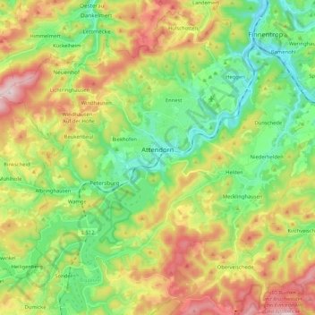
Name: Attendorn topographic map, elevation, terrain.
Location: Attendorn, Kreis Olpe, North Rhine – Westphalia, 57439, Germany (51.07271 7.79579 51.17069 8.00401)
Average elevation: 384 m
Minimum elevation: 229 m
Maximum elevation: 630 m
Make a donation
Gear up for your next adventure:
As an Amazon Associate, this site earns from qualifying purchases at no extra cost to you.