
Lake Powell topographic map
Interactive map
Click on the map to display elevation.
About this map
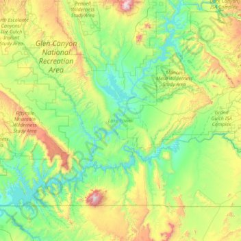
Name: Lake Powell topographic map, elevation, terrain.
Location: Lake Powell, San Juan County, Utah, Verenigde Staten (36.84441 -111.56748 37.90938 -110.28672)
Average elevation: 1,555 m
Minimum elevation: 1,103 m
Maximum elevation: 3,236 m
Other topographic maps
Click on a map to view its topography, its elevation and its terrain.
Blanding
Verenigde Staten > Utah > San Juan County
Blanding, San Juan County, Utah, 84511, Verenigde Staten
Average elevation: 1,851 m