
Padberg topographic map
Interactive map
Click on the map to display elevation.
About this map
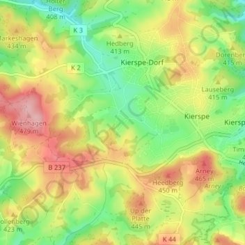
Name: Padberg topographic map, elevation, terrain.
Average elevation: 407 m
Minimum elevation: 342 m
Maximum elevation: 480 m
Other topographic maps
Click on a map to view its topography, its elevation and its terrain.
Vor den Eicken
Deutschland > Nordrhein-Westfalen > Märkischer Kreis > Kierspe-Dorf
Vor den Eicken, Kierspe-Dorf, Kierspe, Märkischer Kreis, Nordrhein-Westfalen, 58566, Deutschland
Average elevation: 406 m