
Make a donation
Gear up for your next adventure:
As an Amazon Associate, this site earns from qualifying purchases at no extra cost to you.
Schleswig-Holstein topographic map
Click on the map to display elevation.
Make a donation
Gear up for your next adventure:
As an Amazon Associate, this site earns from qualifying purchases at no extra cost to you.
Schleswig-Holstein
The Baltic Sea coast in the east of Schleswig-Holstein is marked by bays, fjords, and cliff lines. Rolling hills (the highest elevation is the Bungsberg at 168 metres or 551 feet) and many lakes are found, especially in the eastern part of Holstein called the Holstein Switzerland and the former Duchy of Lauenburg (Herzogtum Lauenburg). The longest river besides the Elbe is the Eider.
Make a donation
Gear up for your next adventure:
As an Amazon Associate, this site earns from qualifying purchases at no extra cost to you.
About this map
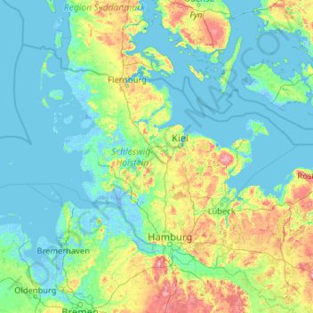
Name: Schleswig-Holstein topographic map, elevation, terrain.
Location: Schleswig-Holstein, Germany (53.35981 7.52116 55.09916 11.67239)
Average elevation: 17 m
Minimum elevation: -6 m
Maximum elevation: 160 m
Make a donation
Gear up for your next adventure:
As an Amazon Associate, this site earns from qualifying purchases at no extra cost to you.
Other topographic maps
Click on a map to view its topography, its elevation and its terrain.
Missen - Pšyne
Germany > Brandenburg > Oberspreewald-Lausitz - Górne Błota-Łužyca > Vetschau/Spreewald
Average elevation: 72 m
Make a donation
Gear up for your next adventure:
As an Amazon Associate, this site earns from qualifying purchases at no extra cost to you.
Wehr (Mosel)
Germany > Rhineland-Palatinate > Landkreis Trier-Saarburg > Palzem > Wehr (Mosel)
Average elevation: 201 m
Leichlingen
Germany > North Rhine-Westphalia > Rheinisch-Bergischer Kreis > Leichlingen > Leichlingen
Average elevation: 95 m
Make a donation
Gear up for your next adventure:
As an Amazon Associate, this site earns from qualifying purchases at no extra cost to you.