
Make a donation
Gear up for your next adventure:
As an Amazon Associate, this site earns from qualifying purchases at no extra cost to you.
Fars Province topographic map
Click on the map to display elevation.
Make a donation
Gear up for your next adventure:
As an Amazon Associate, this site earns from qualifying purchases at no extra cost to you.
About this map
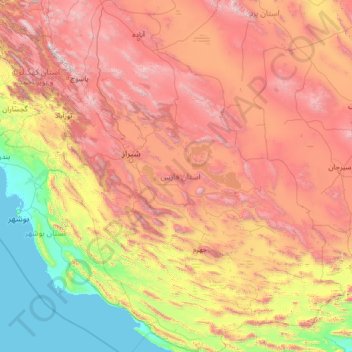
Name: Fars Province topographic map, elevation, terrain.
Location: Fars Province, Iran (27.06802 50.60318 31.66964 55.73296)
Average elevation: 1,339 m
Minimum elevation: -2 m
Maximum elevation: 4,174 m
Make a donation
Gear up for your next adventure:
As an Amazon Associate, this site earns from qualifying purchases at no extra cost to you.
Other topographic maps
Click on a map to view its topography, its elevation and its terrain.
Shurab
Iran > South Khorasan Province > Birjand County > دهستان شاخن > Foorjan
Average elevation: 1,935 m
Espakeh
Iran > Sistan and Baluchestan Province > Lashar County > دهستان لاشارشمالی
Average elevation: 776 m
Now
Iran > Chaharmahal and Bakhtiyari Province > Lordegan County > Sardasht Rural District
Average elevation: 1,871 m
Make a donation
Gear up for your next adventure:
As an Amazon Associate, this site earns from qualifying purchases at no extra cost to you.
Gold
Iran > Chaharmahal and Bakhtiyari Province > Lordegan County > Sardasht Rural District
Average elevation: 1,739 m
Make a donation
Gear up for your next adventure:
As an Amazon Associate, this site earns from qualifying purchases at no extra cost to you.
Shalan
Iran > Kermanshah Province > Kermanshah County > (هوره سو)دهستان قره سو
Average elevation: 1,515 m
Make a donation
Gear up for your next adventure:
As an Amazon Associate, this site earns from qualifying purchases at no extra cost to you.
Make a donation
Gear up for your next adventure:
As an Amazon Associate, this site earns from qualifying purchases at no extra cost to you.
Make a donation
Gear up for your next adventure:
As an Amazon Associate, this site earns from qualifying purchases at no extra cost to you.
Kerrawa
Iran > Kurdistan Province > Sarvabad County > دهستان رزآب > Kerrawa
Average elevation: 1,426 m
Sib
Iran > Sistan and Baluchestan Province > Sib and Suran County > دهستان سیب وسوران > Sib
Average elevation: 1,146 m
Make a donation
Gear up for your next adventure:
As an Amazon Associate, this site earns from qualifying purchases at no extra cost to you.