Geolocate

Fairfield topographic map

Click on the map to display elevation.

About this map

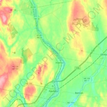
Name: Fairfield topographic map, elevation, terrain.

Location: Fairfield, Somerset County, Maine, United States (44.57732 -69.78027 44.70068 -69.57851)

Average elevation: 64 m

Minimum elevation: 12 m

Maximum elevation: 146 m

Gear up for your next adventure:

📕Australia Maps - Maps covering Australian regions
🦟Insect Repellent - Protection against insects
🥾Hiking Shoes - Lightweight hiking shoes for day hikes
🧊Insulated Cooler Bags - Keep food fresh for day trips to remote geographic sites
📱Shockproof Phone Cases - Extra protection for your smartphone against drops on rocky terrain

As an Amazon Associate, this site earns from qualifying purchases at no extra cost to you.