
Make a donation
Gear up for your next adventure:
As an Amazon Associate, this site earns from qualifying purchases at no extra cost to you.
Gouland topographic map
Click on the map to display elevation.
Make a donation
Gear up for your next adventure:
As an Amazon Associate, this site earns from qualifying purchases at no extra cost to you.
About this map
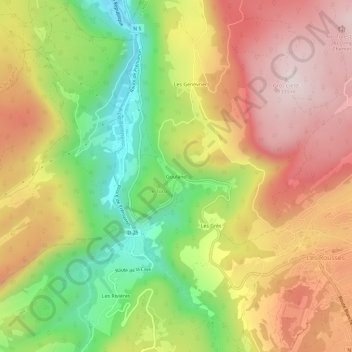
Name: Gouland topographic map, elevation, terrain.
Average elevation: 1,017 m
Minimum elevation: 715 m
Maximum elevation: 1,289 m
Make a donation
Gear up for your next adventure:
As an Amazon Associate, this site earns from qualifying purchases at no extra cost to you.
Other topographic maps
Click on a map to view its topography, its elevation and its terrain.
Lac des Rousses
France > Bourgogne-Franche-Comté > Jura > Les Rousses
Le lac est situé sur la commune des Rousses, au nord-est du village, dans le département du Jura, non loin de la frontière franco-suisse. Grâce à sa situation en altitude, il gèle en période hivernale, ce qui permet d'y pratiquer le patin à glace et le char à voile. Lac de surcreusement glaciaire, il…
Average elevation: 1,130 m