
Thank you for supporting this site ❤️
Make a donation
Make a donation
Gear up for your next adventure:
As an Amazon Associate, this site earns from qualifying purchases at no extra cost to you.
Pavona topographic map
Click on the map to display elevation.
Thank you for supporting this site ❤️
Make a donation
Make a donation
Gear up for your next adventure:
As an Amazon Associate, this site earns from qualifying purchases at no extra cost to you.
About this map
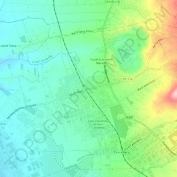
Name: Pavona topographic map, elevation, terrain.
Location: Pavona, Albano Laziale, Roma Capitale, Lazio, 00041, Italy (41.70460 12.59163 41.74460 12.63163)
Average elevation: 188 m
Minimum elevation: 129 m
Maximum elevation: 332 m
Thank you for supporting this site ❤️
Make a donation
Make a donation
Gear up for your next adventure:
As an Amazon Associate, this site earns from qualifying purchases at no extra cost to you.