
American River topographic map
Interactive map
Click on the map to display elevation.
About this map
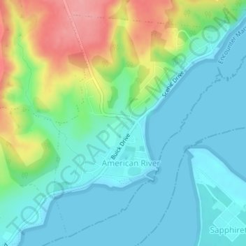
Name: American River topographic map, elevation, terrain.
Average elevation: 30 m
Minimum elevation: 0 m
Maximum elevation: 103 m
Other topographic maps
Click on a map to view its topography, its elevation and its terrain.
Kangaroo Island
Australia > South Australia > Kangaroo Island Council
Kangaroo Island, Kangaroo Island Council, South Australia, Australia
Average elevation: 22 m
Flinders Chase
Australia > South Australia > Kangaroo Island Council
Flinders Chase, Kangaroo Island Council, South Australia, 5223, Australia
Average elevation: 94 m
Wisanger
Australia > South Australia > Kangaroo Island Council
Wisanger, Kangaroo Island Council, South Australia, 5223, Australia
Average elevation: 38 m
Kingscote
Australia > South Australia > Kangaroo Island Council
Kingscote, Kangaroo Island Council, South Australia, 5223, Australia
Average elevation: 7 m
Cape Willoughby Conservation Park
Australia > South Australia > Kangaroo Island Council
Cape Willoughby Conservation Park, Kangaroo Island Council, South Australia, Australia
Average elevation: 12 m
Nepean Bay
Australia > South Australia > Kangaroo Island Council
Nepean Bay, Kangaroo Island Council, South Australia, 5223, Australia
Average elevation: 25 m