
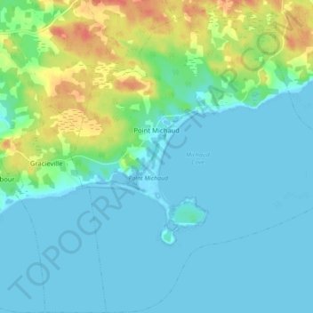
Point Michaud topographic map
Interactive map
Click on the map to display elevation.
About this map
Name: Point Michaud topographic map, elevation, terrain.
Average elevation: 12 m
Minimum elevation: -2 m
Maximum elevation: 48 m
Other topographic maps
Click on a map to view its topography, its elevation and its terrain.
Balmoral
Canada > Nova Scotia > Municipality of the County of Richmond
Balmoral, Grande Anse, Municipality of the County of Richmond, Richmond County, Nova Scotia, B0E 3K0, Canada
Average elevation: 55 m
Flat Rock
Canada > Nova Scotia > Municipality of the County of Richmond > Grand River
Flat Rock, Grand River, Municipality of the County of Richmond, Richmond County, Nova Scotia, Canada
Average elevation: 5 m
Cleveland
Canada > Nova Scotia > Municipality of the County of Richmond
Cleveland, Municipality of the County of Richmond, Richmond County, Nova Scotia, Canada
Average elevation: 40 m
Louisdale
Canada > Nova Scotia > Municipality of the County of Richmond
Louisdale, Municipality of the County of Richmond, Richmond County, Nova Scotia, B0E 1V0, Canada
Average elevation: 26 m