
Chana topographic map
Interactive map
Click on the map to display elevation.
About this map
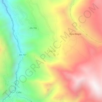
Name: Chana topographic map, elevation, terrain.
Location: Chana, San Pedro de Chaná, Huari, Áncash, Perú (-9.42328 -77.03126 -9.38328 -76.99126)
Average elevation: 3,445 m
Minimum elevation: 2,721 m
Maximum elevation: 4,183 m
Other topographic maps
Click on a map to view its topography, its elevation and its terrain.
Wishllac
Perú > Áncash > San Pedro de Chaná > Huancayoc
Wishllac, Huancayoc, San Pedro de Chaná, Huari, Áncash, Perú
Average elevation: 3,991 m
Santa Cruz de Pichiu
Perú > Áncash > San Pedro de Chaná
Santa Cruz de Pichiu, San Pedro de Chaná, Huari, Áncash, Perú
Average elevation: 3,838 m