
Feeding Hills topographic map
Interactive map
Click on the map to display elevation.
About this map
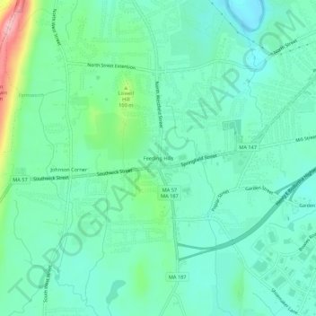
Name: Feeding Hills topographic map, elevation, terrain.
Average elevation: 69 m
Minimum elevation: 31 m
Maximum elevation: 191 m
Other topographic maps
Click on a map to view its topography, its elevation and its terrain.
West Agawam
United States > Massachusetts > Hampden County > Agawam > West Agawam
West Agawam, Agawam, Hampden County, Massachusetts, 01001, United States
Average elevation: 50 m
Hubbard Corner
United States > Massachusetts > Hampden County > Agawam > Hubbard Corner
Hubbard Corner, Agawam, Hampden County, Massachusetts, 01001, United States
Average elevation: 38 m