
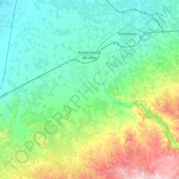
Argamasilla de Alba topographic map
Interactive map
Click on the map to display elevation.
About this map
Name: Argamasilla de Alba topographic map, elevation, terrain.
Average elevation: 717 m
Minimum elevation: 648 m
Maximum elevation: 929 m
Other topographic maps
Click on a map to view its topography, its elevation and its terrain.
Alcázar de San Juan
España > Castilla-La Mancha > La Mancha
Alcázar de San Juan, La Mancha, Ciudad Real, Castilla-La Mancha, 13600, España
Average elevation: 656 m
Rompecalzas
España > Castilla-La Mancha > La Mancha > Pedro Muñoz
Rompecalzas, Pedro Muñoz, La Mancha, Ciudad Real, Castilla-La Mancha, 13620, España
Average elevation: 662 m
Manzanares
España > Castilla-La Mancha > La Mancha
Manzanares, La Mancha, Ciudad Real, Castilla-La Mancha, 13200, España
Average elevation: 681 m
El Barranco
España > Castilla-La Mancha > La Mancha > Villarta de San Juan
El Barranco, Villarta de San Juan, La Mancha, Ciudad Real, Castilla-La Mancha, 13210, España
Average elevation: 635 m
La Solana
España > Castilla-La Mancha > La Mancha
La Solana, La Mancha, Ciudad Real, Castilla-La Mancha, España
Average elevation: 736 m