Geolocate

Red Bluff topographic map

Click on the map to display elevation.

About this map
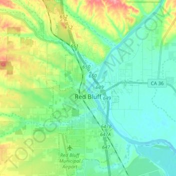
Name: Red Bluff topographic map, elevation, terrain.

Location: Red Bluff, Tehama County, California, 96080, United States (40.13510 -122.26641 40.23084 -122.19677)

Average elevation: 103 m

Minimum elevation: 74 m

Maximum elevation: 176 m

Other topographic maps

Click on a map to view its topography, its elevation and its terrain.
Gerber

United States > California > Tehama County

Gerber is a census-designated place (CDP) in Tehama County, California. Gerber sits at an elevation of 226 feet (69 m). The 2020 United States census reported Gerber's population was 1,044.

Average elevation: 72 m

Loybas Hill

United States > California > Tehama County

Average elevation: 60 m

Loybas Hill

United States > California > Tehama County

Average elevation: 60 m

Beegum Peak

United States > California > Tehama County

Average elevation: 920 m

Gear up for your next adventure:

📱Tablet Tripod Mounts - Steady platforms for viewing digital maps or taking long exposures
🎒Tactical Waist Packs - Quick access to your compass, phone, and snacks while walking
🕶️Polarized Outdoor Sunglasses - Reduce glare from rocks and water for better visual navigation
🥾Heavy Duty Hiking Boots - Ankle-supporting boots for carrying heavy packs on steep contours
🏕️Camping Gear - Essential camping equipment

As an Amazon Associate, this site earns from qualifying purchases at no extra cost to you.