
Make a donation
Gear up for your next adventure:
As an Amazon Associate, this site earns from qualifying purchases at no extra cost to you.
Tonatico topographic map
Click on the map to display elevation.
Make a donation
Gear up for your next adventure:
As an Amazon Associate, this site earns from qualifying purchases at no extra cost to you.
Tonatico
Tonatico has several nearby mountains, including La Cruz and Tapachichi. The largest is La Puerta at 1,685 meters of elevation. The Salto de Zumpantitlán waterfall is nearby, along with the Tenancingo, San Geronimo and Taplalla rivers.
Make a donation
Gear up for your next adventure:
As an Amazon Associate, this site earns from qualifying purchases at no extra cost to you.
About this map
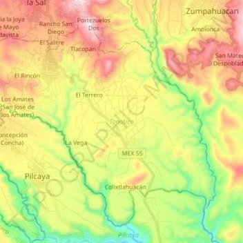
Name: Tonatico topographic map, elevation, terrain.
Location: Tonatico, State of Mexico, Mexico (18.72033 -99.71230 18.83346 -99.57373)
Average elevation: 1,617 m
Minimum elevation: 1,201 m
Maximum elevation: 2,105 m
Make a donation
Gear up for your next adventure:
As an Amazon Associate, this site earns from qualifying purchases at no extra cost to you.