
Arenas topographic map
Interactive map
Click on the map to display elevation.
About this map
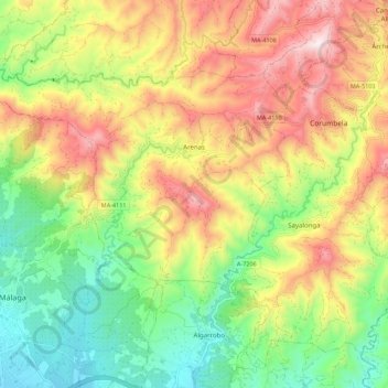
Name: Arenas topographic map, elevation, terrain.
Location: Arenas, La Axarquía, Málaga, Andalusië, Spanje (36.77277 -4.12733 36.83784 -4.01724)
Average elevation: 353 m
Minimum elevation: 18 m
Maximum elevation: 772 m
Other topographic maps
Click on a map to view its topography, its elevation and its terrain.
Las Casillas
Spanje > Andalusië > La Axarquía > Arenas
Las Casillas, Arenas, La Axarquía, Málaga, Andalusië, 29750, Spanje
Average elevation: 263 m