
Make a donation
Gear up for your next adventure:
As an Amazon Associate, this site earns from qualifying purchases at no extra cost to you.
Balkans topographic map
Click on the map to display elevation.
Make a donation
Gear up for your next adventure:
As an Amazon Associate, this site earns from qualifying purchases at no extra cost to you.
About this map
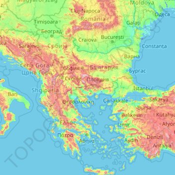
Name: Balkans topographic map, elevation, terrain.
Location: Balkans, Bulgaria (36.38534 13.42757 45.90891 29.61922)
Average elevation: 288 m
Minimum elevation: -4 m
Maximum elevation: 2,928 m
Make a donation
Gear up for your next adventure:
As an Amazon Associate, this site earns from qualifying purchases at no extra cost to you.
Other topographic maps
Click on a map to view its topography, its elevation and its terrain.
Rhodope Mountains
In geomorphological terms, the Rhodopes are part of the Rila-Rhodope massif, which is the oldest landmass on the Balkan peninsula. The Rhodopes are spread over 14,735 square kilometers (5,689 sq mi), of which 12,233 square kilometers (4,723 sq mi) are on Bulgarian territory. They have the greatest extent of…
Average elevation: 501 m
Bansko
Bansko (Bulgarian: Банско [ˈbansko]) is a town in southwestern Bulgaria, located at the foot of the Pirin Mountains at an elevation of 1200m above sea level. It is a ski resort.
Average elevation: 1,034 m
Make a donation
Gear up for your next adventure:
As an Amazon Associate, this site earns from qualifying purchases at no extra cost to you.
Make a donation
Gear up for your next adventure:
As an Amazon Associate, this site earns from qualifying purchases at no extra cost to you.
Make a donation
Gear up for your next adventure:
As an Amazon Associate, this site earns from qualifying purchases at no extra cost to you.
Make a donation
Gear up for your next adventure:
As an Amazon Associate, this site earns from qualifying purchases at no extra cost to you.
Belmeken
Belmeken (Bulgarian: Белмекен) is a summit in the northeastern part of the Rila Mountain in southwestern Bulgaria with a height of 2,626 m. It is built up of granite. Its northern slopes are steep and rise over the Kutlinite cirque. The southern and southeastern slopes are oblique. To the southeast at…
Average elevation: 2,300 m
Make a donation
Gear up for your next adventure:
As an Amazon Associate, this site earns from qualifying purchases at no extra cost to you.
Bansko
Bansko lies at the foot of the Pirin Mountains, not far from the national park of the same name, in the valley of the Nestos River at an elevation of 925 meters above sea level. It is a ski resort. The city is about 160 km from Sofia and about 220 km from Thessaloniki.
Average elevation: 1,034 m
Make a donation
Gear up for your next adventure:
As an Amazon Associate, this site earns from qualifying purchases at no extra cost to you.
Sandanski
Sandanski has developed in an amphitheatrical fashion on the outer south-west flanks of Pirin Mountains along the lower reaches of Sandanska Bistritsa River. The town's altitude varies between 240 and 300 meters. Its geographical location between Kresna and Rupel Gorges determines the town's mild winter and…
Average elevation: 276 m
Dospat
The town was probably founded by Despot Alexius Slav in the 12th or 13th century, from whose title (despot) its name is very likely derived. Dospat Dam is the highest dam in Bulgaria by altitude and, with its 22 km2 of water area, the second largest in capacity. It is fed by the River Dospat.
Average elevation: 1,304 m
Make a donation
Gear up for your next adventure:
As an Amazon Associate, this site earns from qualifying purchases at no extra cost to you.
Make a donation
Gear up for your next adventure:
As an Amazon Associate, this site earns from qualifying purchases at no extra cost to you.
Make a donation
Gear up for your next adventure:
As an Amazon Associate, this site earns from qualifying purchases at no extra cost to you.
Bansko
Bansko lies at the foot of the Pirin Mountains, not far from the national park of the same name, in the valley of the Nestos River at an elevation of 925 meters above sea level. It is a ski resort. The city is about 160 km from Sofia and about 220 km from Thessaloniki.
Average elevation: 1,034 m
Make a donation
Gear up for your next adventure:
As an Amazon Associate, this site earns from qualifying purchases at no extra cost to you.
Make a donation
Gear up for your next adventure:
As an Amazon Associate, this site earns from qualifying purchases at no extra cost to you.
Make a donation
Gear up for your next adventure:
As an Amazon Associate, this site earns from qualifying purchases at no extra cost to you.
Make a donation
Gear up for your next adventure:
As an Amazon Associate, this site earns from qualifying purchases at no extra cost to you.
Make a donation
Gear up for your next adventure:
As an Amazon Associate, this site earns from qualifying purchases at no extra cost to you.
Vitosha
Due to a great variability in elevation, a rich diversity of climates, flora and fauna can be found within the park. Research has revealed that on the comparatively small area of the mountain there are 1,500 species of higher plants, 500 species of fungi, 500 species of algae, 326 species of mosses, and 200…
Average elevation: 2,105 m
Pasarel
Bulgaria > Sofia-City > Dolni Pasarel
The Pasarel dam and reservoir is located 20 km to the southeast of Sofia, Bulgaria at an altitude of 700 m.
Average elevation: 822 m
Make a donation
Gear up for your next adventure:
As an Amazon Associate, this site earns from qualifying purchases at no extra cost to you.
Make a donation
Gear up for your next adventure:
As an Amazon Associate, this site earns from qualifying purchases at no extra cost to you.
Make a donation
Gear up for your next adventure:
As an Amazon Associate, this site earns from qualifying purchases at no extra cost to you.
Make a donation
Gear up for your next adventure:
As an Amazon Associate, this site earns from qualifying purchases at no extra cost to you.
Make a donation
Gear up for your next adventure:
As an Amazon Associate, this site earns from qualifying purchases at no extra cost to you.
Make a donation
Gear up for your next adventure:
As an Amazon Associate, this site earns from qualifying purchases at no extra cost to you.
Make a donation
Gear up for your next adventure:
As an Amazon Associate, this site earns from qualifying purchases at no extra cost to you.
Make a donation
Gear up for your next adventure:
As an Amazon Associate, this site earns from qualifying purchases at no extra cost to you.
Dobrinishte
Dobrinishte (Bulgarian: Добринище [dobˈriniʃtɛ]) is a small town and ski resort in the Blagoevgrad Province, Bansko Municipality, southwestern Bulgaria. As of 2006 it had 2973 inhabitants. It is located 6 km east of Bansko, a famous winter resort. It has an altitude of 850 m and is surrounded by…
Average elevation: 988 m
Make a donation
Gear up for your next adventure:
As an Amazon Associate, this site earns from qualifying purchases at no extra cost to you.
Make a donation
Gear up for your next adventure:
As an Amazon Associate, this site earns from qualifying purchases at no extra cost to you.
Make a donation
Gear up for your next adventure:
As an Amazon Associate, this site earns from qualifying purchases at no extra cost to you.