
Make a donation
Gear up for your next adventure:
As an Amazon Associate, this site earns from qualifying purchases at no extra cost to you.
Blauer See topographic map
Click on the map to display elevation.
Make a donation
Gear up for your next adventure:
As an Amazon Associate, this site earns from qualifying purchases at no extra cost to you.
About this map
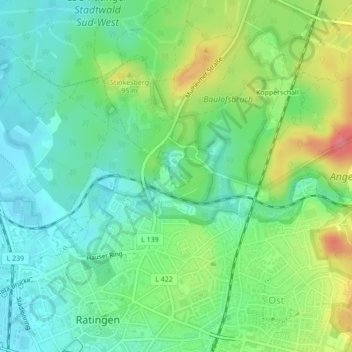
Name: Blauer See topographic map, elevation, terrain.
Average elevation: 69 m
Minimum elevation: 44 m
Maximum elevation: 117 m
Make a donation
Gear up for your next adventure:
As an Amazon Associate, this site earns from qualifying purchases at no extra cost to you.
Other topographic maps
Click on a map to view its topography, its elevation and its terrain.
Breitscheid
Deutschland > Nordrhein-Westfalen > Kreis Mettmann > Ratingen
Neben den im Mittelalter im gesamten Rheinland üblichen „Kugeltöpfen“ in unterschiedlichen Formaten, zeichnet sich die Töpfertradition der „Breitscheider Irdenware“ insbesondere durch die Herstellung großformatiger bauchiger Vorratsgefäße mit und ohne Standhilfe und einer Höhe bis zu 55 cm sowie…
Average elevation: 75 m
Lintorf
Deutschland > Nordrhein-Westfalen > Kreis Mettmann > Ratingen
Lintorf ist ein Stadtteil im nordwestlichen Gebiet der Stadt Ratingen am Übergang des Vorlandes des Bergischen Landes in die niederrheinische Tiefebene. Eine bäuerliche Waldsiedlung am Dickelsbach wurde als Linthorpe im Jahr 1052 erstmals urkundlich erwähnt, die ältesten gefundenen Anzeichen für…
Average elevation: 52 m
Make a donation
Gear up for your next adventure:
As an Amazon Associate, this site earns from qualifying purchases at no extra cost to you.