Geolocate

Weatherford topographic map

Click on the map to display elevation.

About this map

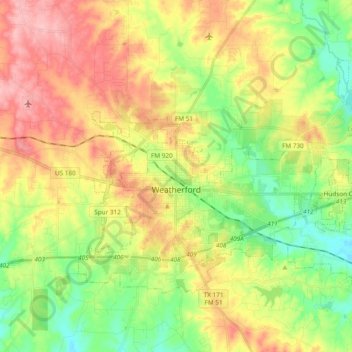
Name: Weatherford topographic map, elevation, terrain.

Location: Weatherford, Parker County, Texas, 76086, United States (32.71167 -97.84999 32.81808 -97.66008)

Average elevation: 326 m

Minimum elevation: 266 m

Maximum elevation: 399 m

Other topographic maps

Click on a map to view its topography, its elevation and its terrain.

Sabathany

United States > Texas > Parker County

Average elevation: 262 m

Peaster

United States > Texas > Parker County

Average elevation: 367 m

Poolville

United States > Texas > Parker County

Average elevation: 358 m

Snake Forest

United States > Texas > Parker County

Average elevation: 312 m

Whitt

United States > Texas > Parker County

Average elevation: 339 m

Authon

United States > Texas > Parker County

Average elevation: 318 m

Slipdown Mountain

United States > Texas > Parker County

Average elevation: 390 m

Brock

United States > Texas > Parker County

Average elevation: 264 m

Dennis

United States > Texas > Parker County

Average elevation: 233 m

Agnes

United States > Texas > Parker County

Average elevation: 351 m

Garner

United States > Texas > Parker County

Average elevation: 296 m

Reno

United States > Texas > Parker County > Reno > Reno

Average elevation: 226 m

Gear up for your next adventure:

🔌Fast Charging Adapters - Quickly top up all your gear before heading back into the field
🚴Cycling Backpacks - Backpacks for cyclists
🏃Compression Recovery Socks - Reduce leg fatigue after heavy days of elevation gain
🛠️Outdoor Repair Kits - Gear repair kits
🪑Portable Backpacking Chairs - A comfortable seat for studying maps at the end of the day

As an Amazon Associate, this site earns from qualifying purchases at no extra cost to you.