
Marienburg topographic map
Interactive map
Click on the map to display elevation.
About this map
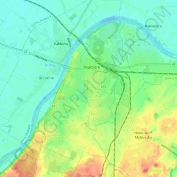
Name: Marienburg topographic map, elevation, terrain.
Average elevation: 17 m
Minimum elevation: -2 m
Maximum elevation: 47 m
1816 wurde die alte Lateinschule durch die Höhere Stadtschule ersetzt, die dann 1860 zu einem vollständigen Gymnasium erweitert wurde.
Other topographic maps
Click on a map to view its topography, its elevation and its terrain.
Kalthof
Polen > Woiwodschaft Pommern > powiat malborski > Marienburg
Kalthof, Marienburg, powiat malborski, Woiwodschaft Pommern, 82-200, Polen
Average elevation: 9 m