Geolocate

Chigwell topographic map

Click on the map to display elevation.

About this map

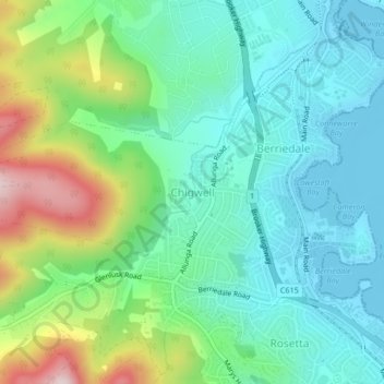
Name: Chigwell topographic map, elevation, terrain.

Location: Chigwell, Hobart, City of Glenorchy, Tasmania, Australia (-42.81502 147.20892 -42.79962 147.25071)

Average elevation: 98 m

Minimum elevation: -2 m

Maximum elevation: 351 m

Tasmania trails, hiking, mountain biking, running and outdoor activities

Other topographic maps

Click on a map to view its topography, its elevation and its terrain.

Snug Falls

Australia > Tasmania > Hobart > Snug

Average elevation: 336 m

Knocklofty

Australia > Tasmania > Hobart

Average elevation: 185 m

Mount Direction

Australia > Tasmania > Hobart

Average elevation: 166 m

Glebe Hill

Australia > Tasmania > Hobart

Average elevation: 66 m

Selfs Point

Australia > Tasmania > Hobart

Average elevation: 17 m

Waterworks Reserve

Australia > Tasmania > Hobart

Average elevation: 240 m

James Austin Park

Australia > Tasmania > Hobart

Average elevation: 25 m

Perrins Ridge

Australia > Tasmania > Hobart

Average elevation: 467 m

Cartwright Point

Australia > Tasmania > Hobart

Average elevation: 59 m

Tolosa Park

Australia > Tasmania > Hobart

Average elevation: 182 m

Glenrose Park

Australia > Tasmania > Hobart

Average elevation: 181 m

Gear up for your next adventure:

Survival Blankets - Emergency thermal blankets
🧺Fast-Dry Microfiber Towels - Large towels that pack down to the size of an orange
🍴Titanium Spork & Cutlery - Indestructible and feather-light eating utensils
🔌Fast Charging Adapters - Quickly top up all your gear before heading back into the field
🧴SPF 50+ Bulk Sunscreen - Maximum protection for long-term outdoor exposure

As an Amazon Associate, this site earns from qualifying purchases at no extra cost to you.