
Make a donation
Gear up for your next adventure:
As an Amazon Associate, this site earns from qualifying purchases at no extra cost to you.
Eichenstruth topographic map
Click on the map to display elevation.
Make a donation
Gear up for your next adventure:
As an Amazon Associate, this site earns from qualifying purchases at no extra cost to you.
Eichenstruth
Das Haufendorf befindet sich etwa sechs Kilometer südsüdöstlich von Betzenstein. auf einer Höhe von 485 m ü. NHN und ist eingebettet in ein Trockental der Fränkischen Alb. Ringsum steigt das Gelände auf Höhen von 530 bis 570 m ü. NHN an. Eichenstruth liegt etwa auf halbem Weg zwischen den jeweils etwa 35 km entfernten Städten Nürnberg im Südwesten und Bayreuth im Nordosten.
Make a donation
Gear up for your next adventure:
As an Amazon Associate, this site earns from qualifying purchases at no extra cost to you.
About this map
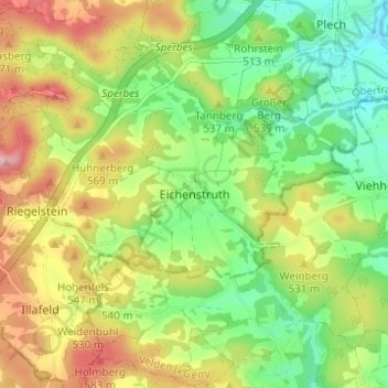
Name: Eichenstruth topographic map, elevation, terrain.
Average elevation: 505 m
Minimum elevation: 431 m
Maximum elevation: 605 m
Make a donation
Gear up for your next adventure:
As an Amazon Associate, this site earns from qualifying purchases at no extra cost to you.