
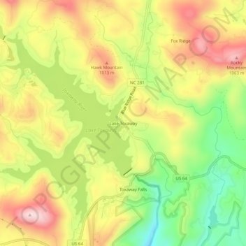
Lake Toxaway topographic map
Interactive map
Click on the map to display elevation.
About this map
Name: Lake Toxaway topographic map, elevation, terrain.
Average elevation: 929 m
Minimum elevation: 768 m
Maximum elevation: 1,081 m
Other topographic maps
Click on a map to view its topography, its elevation and its terrain.
Sapphire
United States > North Carolina > Transylvania County
Sapphire, Transylvania County, North Carolina, 28774, United States
Average elevation: 997 m
Sequoyah Woods
United States > North Carolina > Transylvania County
Sequoyah Woods, Transylvania County, North Carolina, United States
Average elevation: 906 m
Hawk Mountain
United States > North Carolina > Transylvania County
Hawk Mountain, Transylvania County, North Carolina, 28747, United States
Average elevation: 946 m
Brevard
United States > North Carolina > Transylvania County
Brevard, Transylvania County, North Carolina, United States
Average elevation: 745 m
Cedar Rock
United States > North Carolina > Transylvania County
Cedar Rock, Transylvania County, North Carolina, 28718, United States
Average elevation: 839 m
Headwaters State Forest
United States > North Carolina > Transylvania County
Headwaters State Forest, Transylvania County, North Carolina, United States
Average elevation: 818 m
Dupont State Recreational Forest
United States > North Carolina > Transylvania County
Dupont State Recreational Forest, Transylvania County, North Carolina, United States
Average elevation: 826 m
Rosman
United States > North Carolina > Transylvania County
Rosman, Transylvania County, North Carolina, United States
Average elevation: 703 m
Cedar Mountain
United States > North Carolina > Transylvania County
Cedar Mountain, Transylvania County, North Carolina, 28718, United States
Average elevation: 878 m
Balsam Grove
United States > North Carolina > Transylvania County
Balsam Grove, Transylvania County, North Carolina, United States
Average elevation: 914 m
Indian Lake Estates
United States > North Carolina > Transylvania County
Indian Lake Estates, Transylvania County, North Carolina, 28747, United States
Average elevation: 976 m
Pickens Mountain
United States > North Carolina > Transylvania County
Pickens Mountain, Transylvania County, North Carolina, 28772, United States
Average elevation: 795 m
Bracken Preserve
United States > North Carolina > Transylvania County
Bracken Preserve, Transylvania County, North Carolina, United States
Average elevation: 883 m
Dupont Lake
United States > North Carolina > Transylvania County
Dupont Lake, Transylvania County, North Carolina, United States
Average elevation: 803 m
Gorges State Park
United States > North Carolina > Transylvania County
Gorges State Park, 976, Transylvania County, North Carolina, 28774, United States
Average elevation: 682 m
Line Runner Ridge
United States > North Carolina > Transylvania County > Line Runner Ridge
Line Runner Ridge, Transylvania County, North Carolina, United States
Average elevation: 822 m
Connestee Falls
United States > North Carolina > Transylvania County
Connestee Falls, Transylvania County, North Carolina, 28772, United States
Average elevation: 835 m
Knob Creek
United States > North Carolina > Transylvania County > Knob Creek
Knob Creek, Transylvania County, North Carolina, 28768, United States
Average elevation: 735 m
Franklin Park
United States > North Carolina > Transylvania County > Brevard > Franklin Park
Franklin Park, Brevard, Transylvania County, North Carolina, 28712, United States
Average elevation: 665 m
Triple Falls
United States > North Carolina > Transylvania County
Triple Falls, Transylvania County, North Carolina, 28718, United States
Average elevation: 768 m
Wolf Ridge
United States > North Carolina > Transylvania County
Wolf Ridge, Transylvania County, North Carolina, 28747, United States
Average elevation: 956 m